The 60-Second Pitch
What's at stake, in plain language, for the community deciding what becomes of these 45 acres.
After Hurricane Helene (September 2024), roughly 40% of Buncombe County's non-urban tree canopy was damaged or downed (NC Forest Service damage appraisal, October 2024: ~89,440 of 223,600 tree acres) [NC Forest Service], and North Carolina sustained $59.6 billion in statewide damage and needs (NC OSBM revised assessment, December 13, 2024: $44.4B direct + $9.4B indirect + $5.8B mitigation) [NC OSBM]. A screening-level SCS-CN stormwater model estimates this 45-acre forest retained between 3.7 and 7.0 million gallons during the Helene event — water that, in the developed-scenario counterfactual, would have run off through Reed Creek and adjacent drainages toward the lower watershed and Five Points. (For comparison, Keller 2022, UNCA Journal of Undergraduate Research, estimates the forest avoids ~2.2 million gallons of runoff in a typical year — the Helene-event figure is a single-storm estimate, not annualized.) The site sits next to the USDA Forest Service's oldest Eastern research station and contains oaks estimated at 150+ years from diameter-at-breast-height measurements — potentially a climate archive back to the 1870s, pending dendrochronology confirmation.
The proposed stadium would be built by a firm with no completed comparable projects, in what would be the smallest market in the USL Championship league (Asheville MSA ~381,000 vs. Chattanooga, currently the league's smallest market, at ~561,000) [FRED]. A New York Times review of U.S. professional soccer-specific stadium projects (Danielle McLean, NYT Real Estate, November 10, 2025) found that of at least 12 completed projects since 2000 that proposed mixed-use housing development, none have been fully realized; only five are partially completed [NYT]. Our financial model estimates the proposed UNCA stadium would generate roughly $34/acre/year in property tax revenue (UNC land is tax-exempt; stadium-improvement tax estimated $25–30M NPV over 30 years), versus an estimated $137/acre/year for mixed-use housing on the 56 acres of cleared land UNCA already owns.
The forest is not an obstacle to UNCA's future. As a research reserve and teaching forest, it IS UNCA's future — the kind of living laboratory that attracts grants, donors, and students that a 5,000-seat stadium in a 3,000-student market never will. UNCA's own faculty already run hundreds of thousands in NSF grants through these woods. The USDA Forest Service's oldest Eastern research station sits next door — an institutional proximity that exists nowhere else in American higher education.
Warren Wilson College, in the same county, approved a 600-acre conservation easement in April 2024 and received a $10M anonymous gift — the largest in its history — in December 2024 [source]. Drew University and the Borough of Madison signed agreements on January 12, 2026, to permanently preserve the 47.3-acre Drew Forest Preserve [source]. The path is proven. The science is clear. The remaining question is whether UNCA's leaders will follow it.
Important Notes on This Analysis
- Scoring is iterative and open to stakeholder revision. The MCDA scores are the analyst's working judgment, derived from documented data and structured criteria, and they have been shared with stakeholders across the spectrum of positions on the decision (members of the UNC Asheville Board of Trustees, leadership at the Land of Sky Regional Council, members of Friends of the UNCA Woods, and others) for substantive review. The analysis is structured to re-run cleanly under any stakeholder-supplied weighting; alternative scoring from any stakeholder group will be incorporated and the rankings re-published. The corrections protocol (see Changelog) records each substantive revision; the most detailed external review to date (May 18, 2026) is fully reflected in this document.
- Financial comparisons are directional, not precise. The stadium's $204M project cost (some news reports cite ~$250M total district cost; the precise figure depends on what is counted) is primarily the developer's investment, not a public expenditure. The direct public cost is the $29M subsidy UNCA intends to seek; UNCA has not yet specified the source [Asheville Watchdog]. Financial figures show relative differences between scenarios.
- Alternative site scenarios depend on feasibility. Two top algorithmic scorers were disqualified on review: 53 Birch St (100/100, cemetery adjacency) and 226 Fairway Dr (90/100, Asheville Muni Golf Course, NRHP-listed). The leading viable candidate is 1568 Brevard Rd (123 ac, County, 90/100). Site-specific assessment is still needed before committing to any alternative.
- Stormwater figures are screening-level estimates (NRCS SCS-CN method with SSURGO soil data). They show relative differences between scenarios, not engineering-grade volumes. For design, HEC-HMS modeling with actual Helene rainfall data is recommended.
- This is a structured analytical framework, not a substitute for engineering-grade impact assessment. It composes geodesign, multi-criteria decision analysis, screening-level stormwater modeling, financial NPV, ecological survey, and regulatory review into a single decision-support package using publicly available data. For project-level commitments, engineering-grade refinements (HEC-HMS hydraulic modeling, dendrochronology, audited financial pro formas, full property-line survey, formal NEPA / Section 106 review where applicable) are appropriate next steps and are noted throughout.
PART I: THE FOREST
The Forest Itself
Before the policy questions, before the financial models, before the scenarios and scores — there is a forest. Forty-five acres of Appalachian oak-hickory woodland on a hillside above Reed Creek, growing on land that was once part of the dairy-farm operations of Dr. Karl Von Ruck's Winyah Sanitarium (founded 1888; the “New Winyah Sanitarium” opened January 1900 at Spears Avenue and Mt. Clare Street). The sanitarium's farm and pasture spanned land now split between the U.S. Forest Service Southern Research Station (to the north) and UNCA's forested properties (to the south). On UNCA's land, the 1989 Hall & Baker archaeological survey documented the stone foundation of a dairy barn, destroyed by fire on February 7, 1959; its walls still stand among the trees, partly buried in leaf litter, partly visible as the retaining walls that follow the slope.
The premier dendrochronology species. Some specimens on site estimated at 150+ years. A single mature oak transpires 40,000+ gallons of water per year and stores 800-900x more carbon than a sapling.
Diameter measurements suggest the oldest oaks have been here since the 1870s — saplings during Reconstruction; through the catastrophic flood of 1916; through the chestnut blight that transformed Appalachian forests in the 1930s; through Hurricane Helene's fury in September 2024. Their rings would hold a climate record older than any weather station in western North Carolina — an inference that increment-core dendrochronology has not yet confirmed, but which is consistent with the DBH-based age estimates and with the documented forest succession timeline.
Beneath the canopy, 73 types of mycorrhizal fungi connect the root systems in a network that has been building for over a century. Spotted salamanders breed in vernal pools each spring. Barred owls hunt at dusk. Three species of native orchid grow in the filtered light. A squawroot — Conopholis americana, a parasitic plant that lives only on oak roots — marks the intimate connection between above and below ground.
People walk here every morning. Students find quiet between classes. Local artist Spencer Beals placed art among the trees — his “Batland” installation, a 25-artist collaboration installed December 2025, was removed by UNCA administration in January 2026 and triggered a walkout of 100+ students, faculty, artists, and community members on Friday, January 16, 2026 [BPR]. The Five Points neighborhood knows the forest as the green wall that absorbs the rain before it reaches their streets.
Next door, at 200 W.T. Weaver Boulevard, the USDA Forest Service has studied Appalachian forests since 1921. The Southern Research Station headquarters sits within walking distance of these oaks. No other campus forest in America has this proximity to a century of federal forestry science.
This is what is at stake. Not an abstract "green space" or a line item on a balance sheet, but a living system that has been growing, sheltering, absorbing, and witnessing for longer than any person alive can remember. What follows is an attempt to understand what this forest is worth — in the multiple registers that "worth" can mean.
39 Years of Canopy Growth (1985–2023)
NLCD satellite data reveals the forest has been growing for four decades — recovering from its agricultural past and approaching maturity just as it faces destruction.
The forest has been recovering for 40 years. The Von Ruck dairy farm ceased operations in the 1950s-60s; natural succession has been rebuilding the canopy ever since. By 2016, the site reached its highest canopy density in the satellite record. Destroying it now would erase four decades of ecological recovery at the moment it approaches maturity.
Asheville Is Urbanizing Around the Forest
NLCD land cover classification (30m, 1985-2023) shows forest declining region-wide as development expands. The UNCA forest is one of the diminishing patches.
As the region urbanizes, remaining forest patches become more ecologically valuable — they are the last habitat, the last stormwater absorbers, the last cooling canopy. The UNCA forest's tree canopy has been growing (25% to 36% dense canopy, per NLCD TCC) even as the surrounding landscape develops. Clearing it now accelerates a trend that is already reducing the region's resilience.
Recent peer-reviewed finding (Zou et al., Nature Ecology & Evolution, 15 May 2026): Larger forest patches have greater per-area productivity. Using global remote-sensing data, spatial modelling, and counterfactual scenarios, the authors document a positive relationship between forest patch size and productivity — implying that preserving many small forest patches does not offset the carbon and ecosystem-function losses from removing larger contiguous forests. Applied here: the 45-acre UNCA forest is not equivalent on a per-acre basis to 45 acres of scattered smaller patches; reducing or fragmenting it costs more than proportional ecosystem function [DOI].
Source: NLCD Annual Tree Canopy Cover (MRLC/USFS, 30m, 1985–2023) · derived from Landsat + Sentinel-2 imagery and USFS Forest Inventory and Analysis (FIA) data via photo-interpretation and machine-learning methods; methods documentation. 9 years sampled (1985–2023). NLCD Annual Land Cover classes grouped: Forest (41+42+43), Developed (21–24), Agriculture (81+82), Other.
42-Year Aerial Timelapse (1982–2024)
42 years of aerial imagery. Click to view full resolution. Arrow keys or buttons to navigate. Auto-advances every 4 seconds.
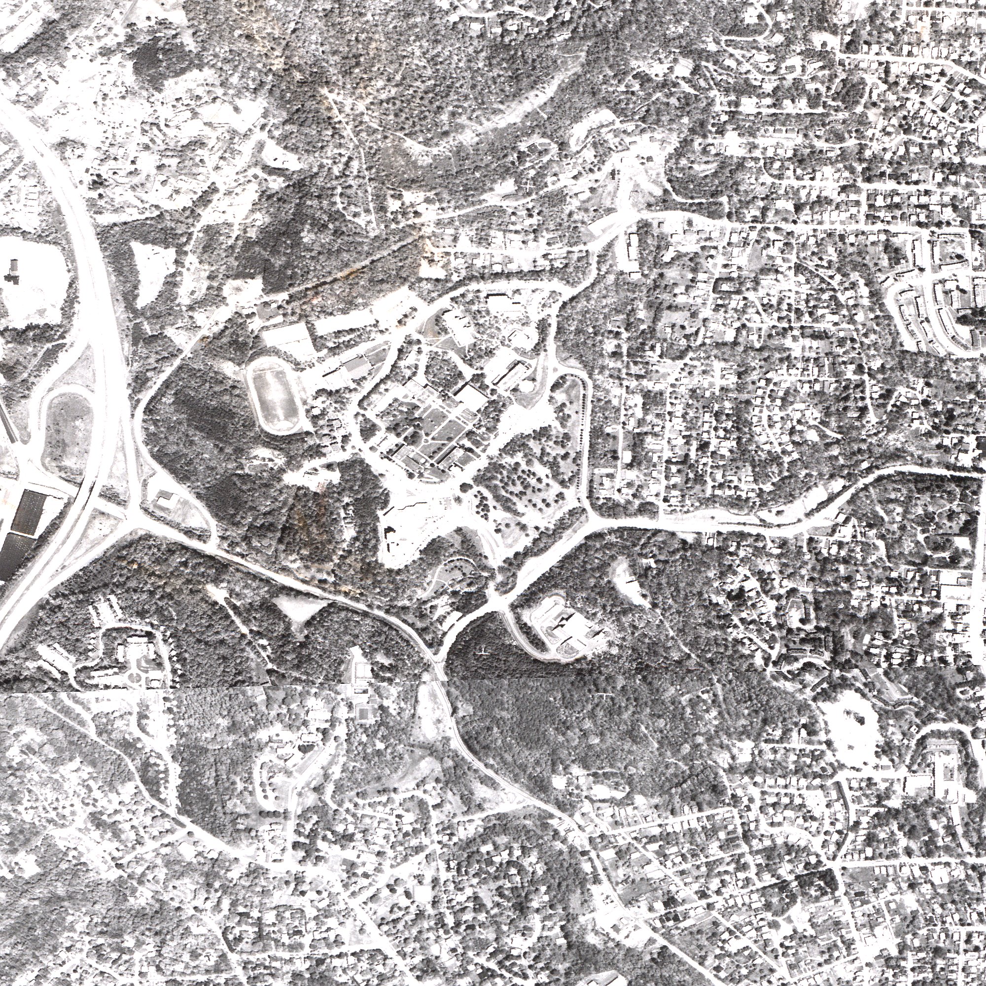
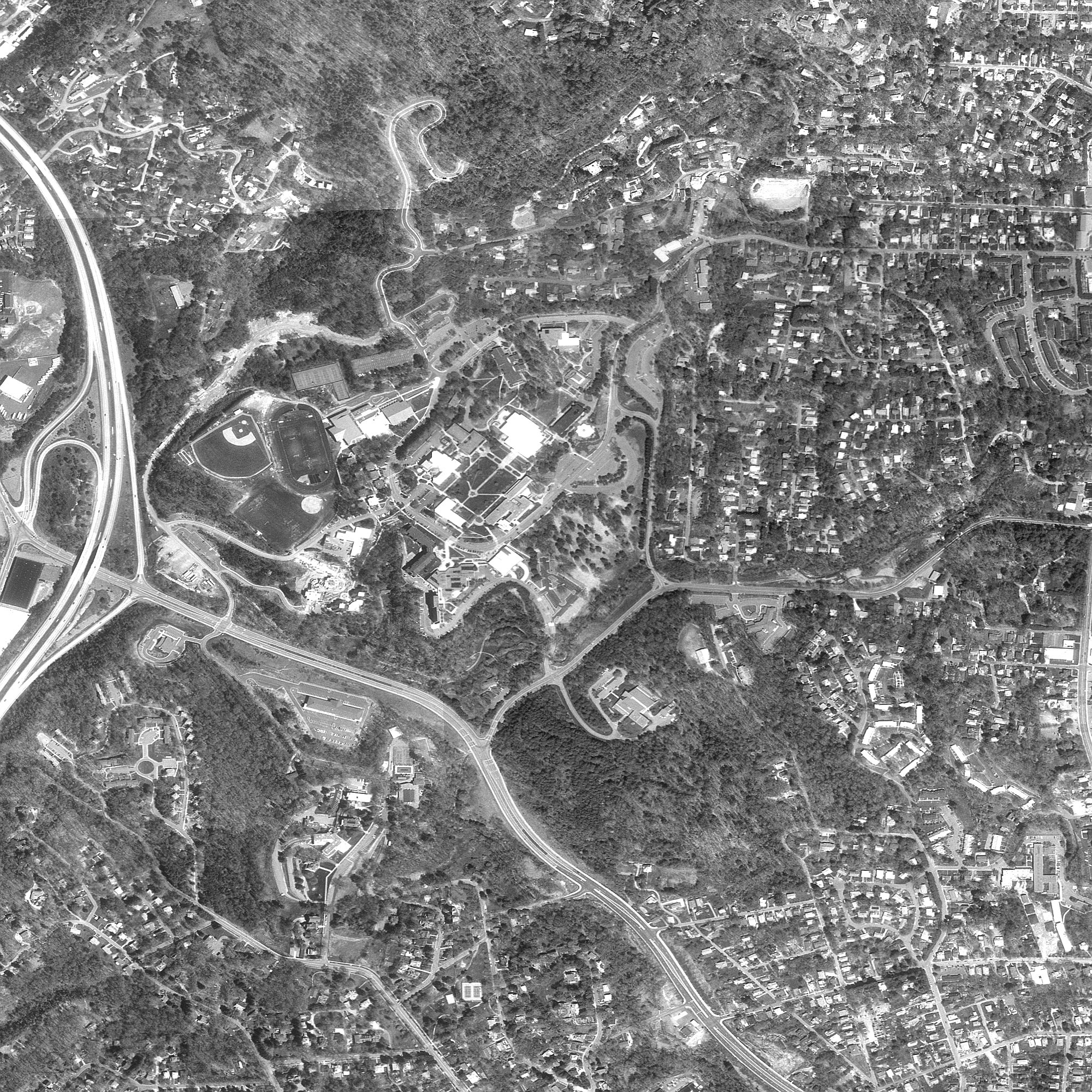
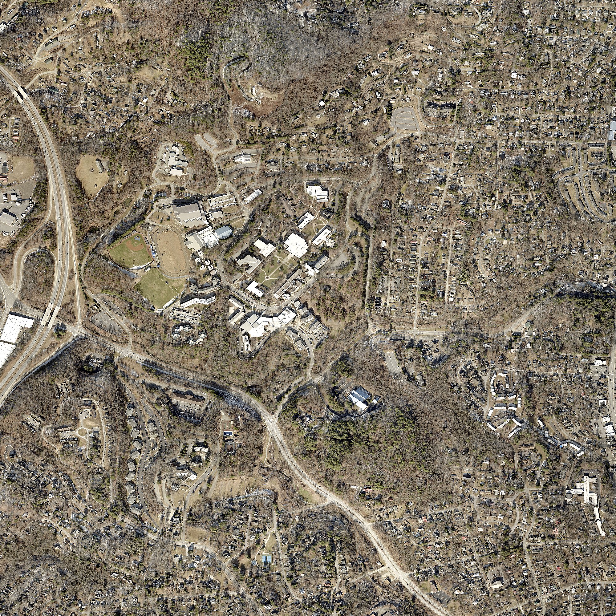
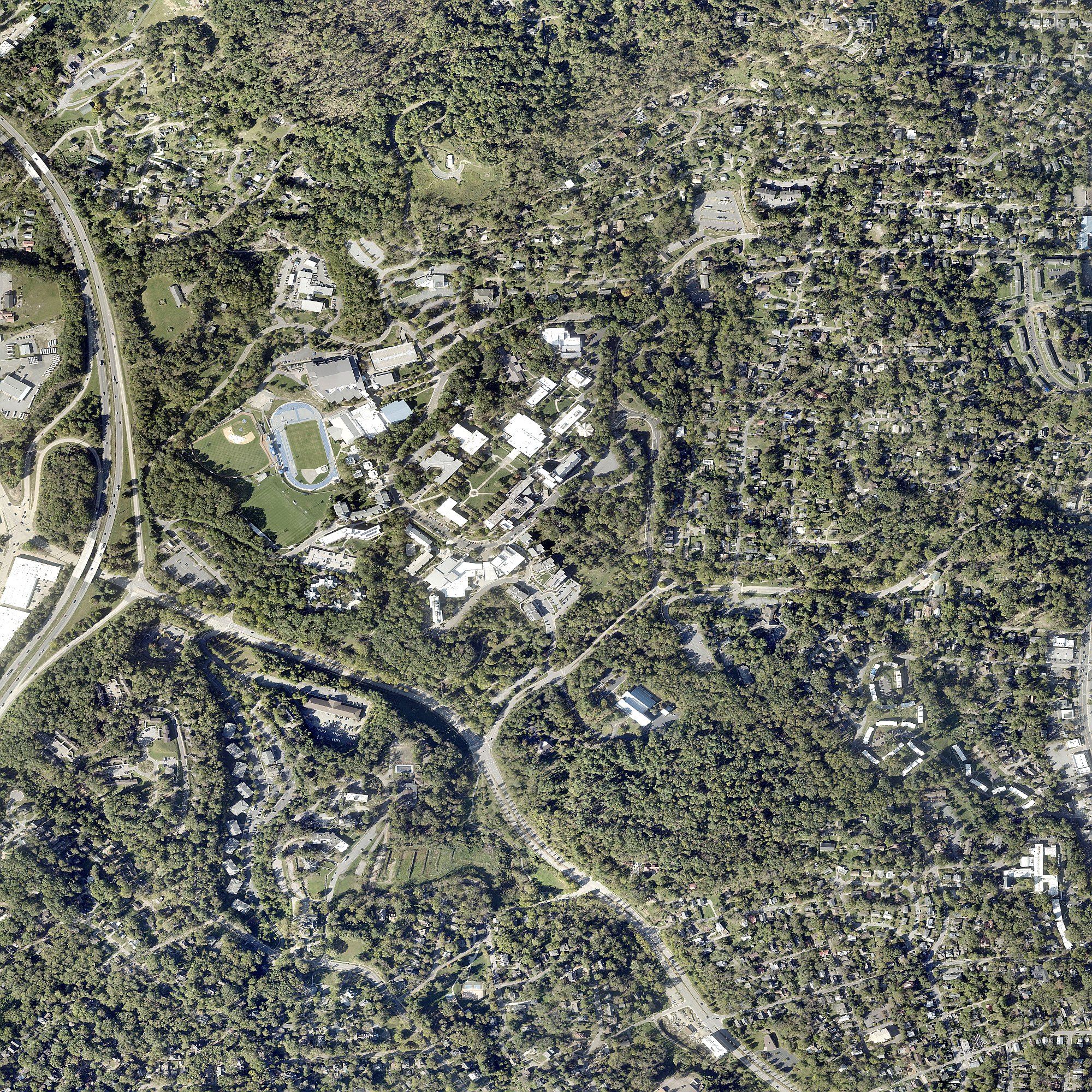
Click image for full resolution. Arrow keys to navigate.
Documented Biodiversity
Community science confirms what ecologists know: this forest is alive with species that depend on intact canopy, connected corridors, and undisturbed soil.
Ambystoma maculatum. Breeds in forest vernal pools each spring. Females lay up to 250 eggs. Recovery after clearing: 50-70 years (Petranka et al., conducted from UNCA Biology).
Species of Conservation Concern
Federally endangered. Requires closed canopy. Stadium lighting would disrupt foraging.
Breeds in vernal pools. Recovery: 50-70 years (Petranka, from UNCA Biology).
Declining nationally. Forest edge supports nectar sources.
IUCN Near Threatened. Survivors are regionally significant.
On-Site Documentation
- 6 oak species (white, chestnut, red, black, post, southern red) — all key dendrochronology species
- 8 native orchid species documented in 2 km radius (downy rattlesnake plantain, crane-fly orchid, putty root, showy orchis, pink lady's slipper, yellow lady's slipper, spring coralroot, slender ladies' tresses) + Galax urceolata (Appalachian endemic) + squawroot + southern blue monkshood + 9 Trillium species + 5 Asarum species (incl. French Broad endemic A. rhombiformis)
- American Black Bear documented in corridor
- Barred owls, great horned owls, screech-owls — sensitive to light and noise
- 73 ECM fungal types on oak seedlings (Walker et al. 2005)
- Wood thrush (down 60% nationally), cerulean warbler (down 72%) — forest interior obligates
Sources: iNaturalist (12,545 obs), 2005 Heiman Environmental Assessment, Petranka et al. 1993, NC Natural Heritage BWHA/NHNA.
The Forest as Economic Infrastructure
The standard analysis frames the forest as competing with development for revenue. The evidence shows the opposite: the forest is the infrastructure that makes the surrounding economy work.
Asheville's tourism economy depends on the city's identity as a place where nature, culture, food, and craft intersect. The breweries, restaurants, galleries, and music venues exist BECAUSE Asheville is the kind of place where people want to be — and that identity is inseparable from the landscape. The forest is not a vacant lot waiting for development. It is a node in a spending path that generates distributed revenue across hundreds of businesses, 365 days a year. The stadium generates concentrated revenue on 90 event days.
Health evidence: Children with nature access show better cognitive function, emotional regulation, and physical health (Kuo & Taylor 2004). Adults near green space show lower depression and anxiety (Bratman et al. 2019, Science Advances). A community that removes its last accessible urban forest is making a decision about the health of generations who have no voice in the process.
FEMA Floodway: A Federal Constraint
10.6 Acres of the Forest Are Federally Regulated Floodway
FEMA National Flood Hazard Layer analysis reveals that the UNCA forest contains 10.6 acres of Special Flood Hazard Area, including a designated FLOODWAY along the Reed Creek corridor. A FEMA floodway is the most restrictive flood zone designation — construction is prohibited unless the applicant demonstrates zero rise in flood levels, a standard that is nearly impossible to meet for a stadium and parking development.
Why this matters: FEMA floodway regulations are federal and cannot be overridden by HB 926 or any state zoning exemption. The developer would need a CLOMR (Conditional Letter of Map Revision) from FEMA before construction in the SFHA — a process that typically takes 6–12 months and requires hydraulic engineering computations proving compliance with NFIP standards (any base-flood-WSEL increase from proposed floodway construction triggers CLOMR requirement) [FEMA LOMR/CLOMR]. The leading viable alternative site (1568 Brevard Rd) has no flood zone constraint.
Source: FEMA National Flood Hazard Layer, Buncombe County (FIPS 37021), effective April 9, 2025. Spatial intersection computed against UNCA parcel boundaries.
Hurricane Helene: The Forest Protection Gradient
Statistical analysis of 1,000 Helene damage assessments shows a clear relationship between distance from the forest and building damage severity.
Near the Forest (0-500m)
- Mean damage: 7.5%
- Undamaged: 47-53%
- Severe damage (>50%): 0%
Far from Forest (2-5km)
- Mean damage: 31.6%
- Undamaged: 6%
- Severe damage (>50%): 21%
Caveat: This is observational correlation, not controlled experiment. Multiple factors besides the forest affect damage severity (elevation, construction type, proximity to streams). Only 18 buildings in the dataset are within 500m of the forest. However, the monotonic gradient across all distance bands is statistically significant and consistent with the stormwater absorption hypothesis.
What the Forest Absorbs
During a Helene-scale storm, the SCS-CN screening model estimates the forest retains 3.7–7.0 million additional gallons compared to the worst-case development scenario (A) — roughly 530–1,000 tanker trucks of water that would otherwise discharge through Reed Creek into the downstream watershed (Botanical Garden, Jackson Park, lower Five Points). This is a screening-level estimate, not engineering-grade modeling.
The undisturbed forest floor absorbs up to 18 inches of rainfall before saturating. Construction compaction reduces infiltration by 70-99%. The mycorrhizal network connecting tree roots takes 80-150+ years to rebuild.
= 5.0 million additional gallons = 688 tanker trucks of water
Calibrated with SSURGO soil data (Tate loam, Clifton sandy loam, Hydrologic Group B). Range: 1.9M–4.9M gallons depending on storm severity (2-yr to Helene-scale) for full development (Scenario A, 85% cleared). Lighter development scenarios (C2, D) produce 0.8M–2.7M.
Environmental Impact: Quantified
Three models quantify what clearing the forest would cost in ecological terms.
Sources: Habitat model uses Hansen treecover2000 + connected component analysis. Heat model based on Ziter et al. (2019) PNAS. Carbon uses Appalachian oak-hickory literature values (191 MgC/ha mature forest). Social cost of carbon from EPA IWG 2021.
Interactive Geodesign Map
Explore 11 GIS data layers including public parcel ownership, floodplains, Hurricane Helene damage, proposed zoning, urban heat vulnerability, transit routes, and more. Toggle layers using the control at top-right. Click any feature for details.
How to read this map. The map shows public-ownership parcels from the Buncombe County parcel dataset (2,000 county features filtered to 80 public parcels) classified by ownership category and title basis. UNC Asheville parcels (34 features, ~118 acres total) are styled blue; South Campus Forest constituent parcels (8 parcels, sum ~61.85 ac — see Forest acreage note below) carry an amber outline. Click any parcel for the title basis and full attributes.
What the map captures — and what it doesn't. The county parcel layer captures land-title polygons. The University of North Carolina at Asheville's academic core is partly visible as several large UNCA-blue parcels along Campus Drive, W.T. Weaver Boulevard, and Vivian Avenue. Some academic buildings sit on smaller individual parcels not in the public-parcels filter, or on land titled in ways the assessor records with non-college landuse codes, so the on-map UNCA footprint will not perfectly match the OSM base map's labeled campus boundary — read the colored polygons as “documented UNCA-administered land in the county feed,” not as a complete campus boundary. The South Campus Forest is the highlighted contiguous green-and-amber cluster south of W.T. Weaver Boulevard. Floodplain and FEMA-zone layers are now styled in lavender to avoid color collision with the UNCA-parcel blue.
Classification rules. “UNCA / UNC System” includes: parcels
directly titled to the University of North Carolina at Asheville or to the UNCA Foundation;
parcels titled to the State of North Carolina located in the Buncombe assessor's
UCAA neighborhood code; and parcels titled to the State of NC in adjacent
UNCA-cluster neighborhoods carrying a GVMT/COLLEGE or generic GVMT
landuse on UNCA-cluster street addresses. The UNC system is itself a state entity, so most
main-campus buildings and most of the forest are titled to the State of North Carolina and
administered by UNCA. State-of-NC parcels that are not UNCA-administered (NC DOT,
A-B Tech, state forests, the “Nut Hill” parcel of uncertain attribution) appear
as “Other Public (State).” Source: Buncombe County GIS, rebuilt 2026-05-19.
Forest acreage note. The “45-acre” figure used throughout the analysis is the working approximation for the South Campus Woods. The rebuilt parcel layer shows that the constituent parcels — depending on which parcels along Vivian Avenue and the Lookout / Nantahala periphery are counted as forest versus main campus or pasture edge — sum to roughly 38–62 acres. A precise on-the-ground forest-boundary survey would tighten this; it is on the open work list. Floodplain and FEMA-zone layers are now styled in lavender to avoid color collision with the UNCA-parcel blue.
Base map tiles from OpenStreetMap (only external resource). All vector data embedded. Full 44-layer data package (4.6 GB) available upon request.
Climate Context: Why This Forest Matters More Every Year
Asheville is warming. The forest's cooling, stormwater, and habitat functions become more valuable with every degree of temperature rise. UNCA undergraduate research on local heat vulnerability is directly relevant: Hope Donnellan (Fall 2023 UNCA Journal of Undergraduate Research), “Developing a Heat Vulnerability Index for Buncombe County, NC,” built a county-specific HVI methodology that this analysis's urban-heat layer is consistent with [UGR 2023 archive].
This is exactly the scenario the City has planned for. Asheville's adopted Living Asheville comprehensive plan (June 2018, City Council-adopted) includes Planning for Climate Resilience (Appendix D), authored over 2016-2018 by a 31-person team of city staff and volunteers in partnership with UNCA's National Environmental Modeling and Analysis Center (NEMAC). Among its quantitative findings: Asheville's 2018 citywide tree canopy was 44.5%, with an adopted goal to restore canopy to 50% by 2040 (requiring ~50,000 trees planted); approximately 3,308 families and 14,510 households with members over 65 are vulnerable to extreme heat events because they live in areas with high developed-land cover and low tree canopy; marginalized communities with little tree canopy register surface temperatures roughly 10°F higher than tree-filled neighborhoods [US Climate Resilience Toolkit]. Clearing 85% of the canopy on the largest contiguous urban forest in this part of the city runs directly against the adopted plan's policy direction.
Myotis septentrionalis. Federally endangered (ESA 2022). Requires closed-canopy forest for roosting. Stadium lighting (500-1,000 lux) would disrupt foraging. Documented in Buncombe County.
The Compounding Loss
Between 2008 and 2018, Asheville lost 891 acres of tree canopy (6.4% decline). The 2019 Asheville Urban Tree Canopy Study quantified the resulting loss of ecosystem services at approximately $8.5 million: $1.6M in increased stormwater runoff costs, $6.85M in lost carbon storage, and $23,500 in lost air-pollution removal — together with roughly 18 million additional gallons of runoff annually and 6,000 tons of carbon no longer absorbed. Then Hurricane Helene destroyed 40% of the remaining county canopy in a single event. The UNCA forest is one of the largest intact patches to survive both development pressure and Helene. Removing it now would compound a loss that is already catastrophic.
Source: Asheville Urban Tree Canopy Study (2019), conducted by Davey Resource Group for the City of Asheville Urban Forestry Commission. Helene canopy-loss estimate via Asheville GreenWorks.
NASA confirmed the link: A 2019 NASA DEVELOP study found significant correlation between tree cover loss and land surface temperature increase in Asheville. Every acre of canopy removed measurably warms the city. (NASA DEVELOP study)
Ecological Corridor
The UNCA forest is the southern terminus of a wildlife corridor from the Blue Ridge Parkway through Craggy Mountains, Beaver Lake (220+ bird species), Reynolds Mountain, and Chestnut Ridge to Pisgah National Forest (500,000+ acres). Severing this corridor at the UNCA link isolates urban wildlife from its mountain refuge.
Health Infrastructure
Buncombe County depression rates reach 32-36% in vulnerable populations (2024 Community Health Assessment). Walk Score near UNCA: 48 (car-dependent). The forest is one of the few places in the area where residents can walk among trees. Nature access reduces depression, anxiety, and cortisol — the forest is mental health infrastructure that no stadium can replace.
Sources: NC Climate Office, NASA DEVELOP 2019, Trust for Public Land ParkServe, CDC PLACES 2024, Walk Score, Buncombe County 2024 CHA, eBird Beaver Lake (220+ species).
PART II: THE COMMUNITY
Understanding the Pressures: Who Faces What
Every actor in this decision is responding to real pressures. A fair analysis must name them all.
UNC Asheville
The institutionThe pressure: 25% enrollment decline (3,900 to 2,914). $6–8M annual deficit. $13M Helene costs. Five chancellors in eight years — the sequence: Anne Ponder, Doug Orr (interim, 2014), Mary K. Grant (2015–17), Joe Urgo (interim, 2017–18), Nancy Cable (2019–22), and Kimberly van Noort (interim Jan 2023, permanent Jan 2024) [Asheville Watchdog]. Departments eliminated.
What they need: Sustainable revenue, enrollment recovery, institutional identity. The stadium was presented as answering all three.
What the evidence shows: Stadium revenue ($1.69M/yr) comes with high risk (smallest USL market, unproven developer, $29M subsidy). Alternatives exist: housing on cleared MC parcels, conservation philanthropy (Warren Wilson: $10M), research grants already flowing through the forest. In a Fall 2025 UNCA campus survey, only 1 of 117 students ranked a stadium among their top three priorities for Millennial Campus development [UNCA MS Environmental Resilience cohort StoryMap, Fall 2025]. National research finds campus appearance is consistently among the top factors in college choice. Surveys of prospective students have found that a significant share — commonly reported in the range of 35–50% across studies, depending on question phrasing — consider the quality of campus facilities and appearance important or highly important to their enrollment decision (e.g., McDonald, Western Kentucky University, 2019; Inside Higher Ed campus-facilities reporting). The forest is the single most distinctive piece of UNCA's campus appearance. (Specific 67% figure previously cited could not be verified against the McDonald 2019 source; citation under review.)
Chancellor & Administration
The decision-makersThe pressure: Chancellor van Noort served as interim chancellor from January 2023 (following Nancy Cable's resignation) and was unanimously elected as the ninth permanent chancellor by the UNC Board of Governors on November 29, 2023, assuming the permanent role January 1, 2024 [UNC System]. She inherited a $6–8M structural deficit, $13M in Helene-recovery costs, and a 25% enrollment decline. The stadium proposal itself emerged during her tenure — the developer LLC was filed November 27, 2024, and the project was publicly announced June 13, 2025.
The opening: She has said she is "open to a different plan" (The Assembly, Feb 26, 2026). Because the stadium plan emerged on her watch rather than as an inheritance, course-correction is a refinement of an in-progress decision, not the repudiation of a predecessor — which lowers, not raises, the political cost. The alternative-sites study gives the administration options that address revenue without community conflict.
State of NC / UNC System
Regulatory contextThe pressure: System-wide enrollment decline. Millennial Campus authority designed for revenue generation. HB 926 (Oct 2025) removed local zoning oversight.
The precedent question: A failed stadium in the smallest USL market would not be a replicable model for 16 UNC campuses. A conservation-to-revenue pathway would be. What precedent does the BOG want to set?
Federal Dimension
Research, recovery, regulatoryUSFS SRS: Adjacent since 1921 (200 W.T. Weaver Blvd). Partnership potential depends on federal priorities — worth exploring, not assumed.
FEMA: $225M CDBG-DR to Asheville. If $29M subsidy includes federal funds, Section 106 requires EBCI consultation.
ESA: Northern long-eared bat (federally endangered) documented in Buncombe County. Closed canopy required habitat.
City & County
Local governmentThe pressure: Housing crisis, post-Helene recovery ($1.3B unmet), tourism economy protection. HB 926 stripped zoning authority but left infrastructure costs.
Comp plan alignment: Living Asheville (2018, City Council-adopted) designates UNCA in the “Employment/Anchor Institution” framework — not as a growth corridor; growth is directed to Urban Centers (I-240, River Arts, South Slope). The neighborhood-level 5 Points Plan on a Page (2018, prepared by the 5 Points Neighborhood Association) states that the neighborhood will “work with UNCA and residents to keep the Urban Forest intact” (Sustainability section, p. 15).
Buncombe County TDA
Tourism Development Authority — capital project funderThe pressure: BCTDA Board of Directors approved the FY26 $25.9M operating budget ($21.7M anticipated net lodging-tax revenue + $4.2M from fund balance) per the Nov 19, 2025 board meeting materials [BCTDA board materials]. Separately, more than $15M is anticipated for community capital project investment through the next Tourism Product Development Fund (TPDF) cycle; the October 2025 TPDF cycle awarded $12.4M across 8 projects [BPR]. Post-2022 NC law allows debt-funded capital investment in tourism infrastructure. Hotel/STR room-tax revenue means the metric-of-record is "heads in beds."
Stated FY26 strategic imperatives (BCTDA): “Delivering Balanced & Sustainable Growth; Encouraging Safe & Responsible Travel; Engaging & Inviting More Diverse Audiences; Promoting & Supporting Asheville's Creative Spirit; Running a Healthy & Effective Organization.” CEO Vic Isley has publicly cited a Supernova Immersive Experience Project — described as an immersive art experience similar to Meow Wolf in Santa Fe — as among the FY26 funded initiatives ($200,000 design allocation) [BCTDA Nov 19 2025 board materials]. The takeaway: BCTDA is funding immersive experiential precedents at small-scale and exploring large-scale capital projects in the same cycle, which is a more nuanced funding posture than “sports facility” alone would describe.
The opening: The 45-acre forest already is an immersive, hands-on environment with year-round appeal — arguably exceeding any building-based attraction at far lower capital cost. Reframing the woods as a TDA-fundable family-friendly experience would use the same public funding pipeline that would otherwise build a stadium. The BCTDA is a public body whose meetings are open and whose contact information is posted at exploreasheville.com.
Community & Residents
The people who live hereFive Points: Unanimously opposed. The 2018 5 Points Plan on a Page (Neighborhood Association vision document) states the neighborhood will “work with UNCA and residents to keep the Urban Forest intact.” Experienced the forest's flood protection during Helene firsthand.
Friends of the UNCA Woods (FOTW): The "Protect the UNCA Urban Forest" petition (hosted on Action Network, sponsored by Friends of UNCA Woods) has gathered 17,000+ signatures (as of 2026-05-19) [Action Network]. Student walkouts. Broad-based — not just neighbors.
Students & Faculty: Only 1 of 117 students ranked a stadium among their top three priorities; only 4 of 65 faculty did (UNCA MSER cohort survey, Fall 2025). UNCA enrollment dropped 6% in Fall 2025 — the only decline among the 16 UNC system campuses (the system overall set a record at 250,000+ students, +3.4%) [UNC System]. Faculty run NSF-funded research through the forest, and 17 biology + 21 environmental science courses use it as a living classroom (StoryMap source).
The Developer
McCullers GroupProfile: Sports advisory firm (~5-6 employees, $3M revenue), Westerville, Ohio. Role: "project executive" (advisor), not developer-of-record. Contractors: Metcon, Blum Construction.
Fair assessment: The developer may genuinely believe in the project. But the model requires every assumption to work in the smallest USL market. A site with better highway visibility and transit access could actually serve the developer's interests better.
Eastern Band of Cherokee Indians
Original stewardsAncestral territory called Togiyasdi ("Where They Race"). EBCI sovereign territory 50 miles west. UNCA's own land acknowledgment recognizes this. Under Section 106 of the National Historic Preservation Act (implementing regulations at 36 CFR Part 800), any federal agency carrying out, licensing, or financially assisting an undertaking that may affect historic properties must take into account those effects and consult with Indian tribes whose ancestral territory the undertaking touches — including for projects off tribal lands. If any federal funds are involved in this project (FEMA recovery dollars, CDBG-DR, USFS partnership, etc.), Section 106 tribal consultation is required. Regardless of legal trigger, consultation is an ethical obligation the current process has not fulfilled.
The Wider Context
This decision sits at the intersection of pressures every community faces:
- Climate: Helene was 10% heavier due to climate change. Extreme events intensifying. Green infrastructure not optional.
- Higher ed fiscal stress: Enrollment cliffs pushing universities toward land monetization. 83% of economists (including 7 Nobel laureates) on the 2017 IGM Forum panel agreed with the statement: “Providing state and local subsidies to build stadiums for professional sports teams is likely to cost the relevant taxpayers more than any local economic benefits that are generated.” Only 4% disagreed; 11% were uncertain (IGM Forum, University of Chicago Booth, 2017).
- Housing: Genuine crisis requiring solutions on appropriate sites at appropriate densities.
- Biodiversity: Global decline. Urban forests as refugia. 1,768 species within 2 km (iNaturalist research-grade, retrieved 2026-04-28) — including 9 species of Trillium and 8 native orchids.
- Governance trust: When processes appear captured, trust erodes. Transparency rebuilds it.
- Community resilience: Post-disaster communities investing in green infrastructure recover faster.
The outcome will be studied by other universities, cities, and communities facing the same intersecting pressures.
UNCA's Own Scholarship vs. UNCA's Administration
UNCA is not a single voice. It is an administration, a Board of Trustees, students, faculty, and alumni — and on this question, those voices diverge sharply. The most direct evidence is a StoryMap published by UNCA's own Master of Science in Environmental Resilience cohort, presenting a class-project assessment of the proposed development against the climate-resilience framework UNCA's faculty teach.
UNCA Scholarship: "Wrap the Woods"
"Vision for a Climate Resilient Campus at UNC Asheville" — ArcGIS StoryMap, Fall 2025 class project produced by the inaugural ten-student cohort of UNCA's MS in Environmental Resilience program for Dr. Kathleen Lawlor's Climate Resilience Foundations course. (Authors and acknowledgments are credited in the StoryMap itself.)
- Applies the U.S. Climate Resilience Toolkit's Steps to Resilience framework (NOAA / NEMAC) to the South Campus Woods decision.
- Surveyed UNCA students & faculty: only 1 of 117 students ranked a stadium in their top three; only 4 of 65 faculty ranked it.
- Quantified ecosystem services per Anna-Lisa Keller (2022), “Inventorying University of North Carolina Asheville's Forested Properties to Assess Carbon Stock,” UNCA Journal of Undergraduate Research 2022 [UGR 2022 archive]: 75.5 t CO₂/yr sequestered, 3,450 t stored (≈ $589K stock value), 294,700 ft³ runoff avoided/yr. Companion 2022 UNCA UGR work by Pierce Lynch (campus tree carbon stocks), Ally Fouts (urban tree canopy as sustainability infrastructure), and Stephanie Meyers (“Carbon Sequestration in the Face of Invasion” — invasive-plant pressure on campus carbon stocks) forms a coherent UNCA undergraduate-research body on the same forest; Leah Given's Fall 2023 paper on carbon storage forecasts for campus trees threatened by invasives extends it forward.
- Documents that 17 biology + 21 environmental science courses use the Woods as a living classroom; the MSER StoryMap cites approximately $688K in active extramural grants referencing the urban forest (the StoryMap is the proximate source for this figure; the underlying grant-by-grant detail is collected through UNCA's Office of Research and Sponsored Programs). UNCA Biology faculty research in the forest has historically been funded by NSF, the NC Biotechnology Center, the McCullough Fellowship, and other extramural sources per the UNCA Education & Research summary.
- Recommends two alternative development proposals (low + medium) on UNCA's cleared Zillicoa property — preserving The Woods while still delivering childcare, student housing, and community space.
Disclaimer in the StoryMap itself: "This research was not conducted on behalf of UNC Asheville or the Millennial Campus Development Planning Commission."
UNCA Administration: The Stadium Plan
5,000-seat stadium + mixed-use development on the 45-acre South Campus Woods — the most carbon-rich, stormwater-absorbing, biodiverse parcel UNCA owns. Announced June 2025; paused August 2025 after the petition reached 15,000+ signatures (now 17,000+).
Helene-context impact: a screening-level SCS-CN model estimates this forest retained 3.7–7.0 million gallons during Helene, water that in a developed-scenario counterfactual would have flowed through Reed Creek toward Five Points and the lower watershed (Botanical Garden, Jackson Park). The same university that teaches the Steps to Resilience framework would, under this plan, dismantle the largest piece of climate-adaptation infrastructure on its campus.
The split, plainly: the institution's scholarship argues for preservation. The institution's administration proposes development. Both are UNCA — and reconciling them requires honoring the scholarship the university itself produces.
The reconciliation: The StoryMap is not an outsider's critique — it is internal scholarship by UNCA's own students and faculty, applying tools the university teaches, against data the university generates. It does not need to be argued against UNCA; it is UNCA. The path that honors it is preservation, with operational financing through the BCTDA capital-project pipeline (see Buncombe County TDA stakeholder block above) — Scenario K in this project's MCDA, ranked top-3 under environmental and resilience weight schemes.
Acknowledgement in the StoryMap: "Special thanks to Save the Woods for compiling many useful resources, and to Scott Burroughs from This Land Studio for guest speaking and sharing his own perspective along with results from their community visioning workshop." Full credits, faculty consultations, and references are listed in the StoryMap itself.
Community Context
Any land-use decision must be understood in the context of who lives here, what they need, and what pressures they face.
City of Asheville (Census QuickFacts · 2020 Census / latest ACS)
| Population (2020 Census) | 94,353 |
| Growth (2010-2020) | +12.4% |
| Median household income (latest ACS) | ~$71,100 |
| Poverty rate (latest ACS) | ~14.3% |
| Median home price (2024 area) | $420K+ |
| Home price increase 2015-2021 | ~+89% |
| Low-income neighborhood spike (2015-2021) | +116% |
| Cost-burdened renters (Buncombe; >30% of income) | ~46% |
| Severely cost-burdened (>50%) | ~19% |
| Race (White / Black / Hispanic, 2020) | ~77% / 12% / 7% |
| Parkland | 3% of city area |
Source: US Census QuickFacts — Asheville city; Bowen National Research / Asheville Housing Market Study.
Buncombe County (Census QuickFacts)
| Population | ~269,000 |
| MSA population (latest FRED) | ~381,000 |
| Median household income (latest ACS) | ~$67,000 |
| Annual visitor spending | $6.4 billion |
| Helene deaths (county) | 43 |
| Helene FEMA applications | 76,000+ |
| Helene unmet needs | $1.3 billion |
| CDBG-DR allocation | $225 million |
| Tree canopy damaged/downed (non-urban, post-Helene) | ~40% |
| Depression rate (vulnerable groups) | 32-36% |
Source: US Census QuickFacts — Buncombe County; FRED ASHPOP; NC OSBM Helene Damage and Needs Assessment.
The Housing Question
Asheville faces a genuine housing crisis: roughly 46% of Buncombe renter households are cost-burdened (paying over 30% of income on housing) and ~19% are severely cost-burdened (over 50% of income); home prices rose ~89% from 2015 to 2021 ($199,800 to $319,400 area-wide); the lowest-income neighborhoods saw 116% price spikes over the same window. Housing is a real need that deserves a real solution. The question is not whether to build housing, but where. UNCA owns 56+ acres of cleared, infrastructure-served land that could deliver housing without destroying the forest. The land-swap scenarios address housing AND preserve the forest AND generate tax revenue — the only approach that serves all three goals simultaneously.
Sources: U.S. Census Bureau ACS 2020-2023, Buncombe County 2024 CHA, FEMA, Trust for Public Land.
Timeline of Events
Process Quality Benchmark
Multiple universities have faced campus forest development conflicts. The outcomes consistently favor institutions that follow a transparent, evidence-based process. Five elements define a credible decision process.
| # | Process Element | Precedent Outcomes | UNCA Status |
|---|---|---|---|
| 1 | Third-party ecological assessment | Virginia Tech: Biohabitats assessment. Drew University: independent review led to 51-acre preservation (Jan 2026). App State: 67-acre campus forest designated State Natural Area (1999). | NOT DONE — Long-term research plots destroyed Jan 2025 before any baseline inventory could be published. |
| 2 | Mixed-stakeholder committee | Virginia Tech: APFSEC with diverse membership. Rider University: community process led to $8.5M county purchase of 56-acre "Big Woods" (Mar 2026). | RAISES QUESTIONS — The 12-member Millennial Campus Development Advisory Committee (per UNCA's own announcement [UNCA]) is composed predominantly of UNCA Board members, alumni, and institutional affiliates. Named current trustees on the committee: Stephen De May, David Meyer, plus co-chair Peter Heckman (BOT Vice Chair) and Lou Bissette (former trustee, former mayor, former UNC BOG chair). Co-chair Adam Walters is a UNCA alumnus at NC State. Victoria Isley serves on the committee as Explore Asheville / BCTDA CEO — an entity that is itself a potential funder of either the proposed stadium or an alternative use under the BCTDA capital pipeline. The committee does not include direct representation from Friends of UNCA Woods, the Five Points neighborhood, the City of Asheville, or Buncombe County. The committee meets in closed sessions through May 2026; HR&A Advisors will synthesize recommendations into the Millennial Campus Action Plan. (See also Asheville Watchdog reporting.) |
| 3 | Written alternatives analysis | Virginia Tech: published alternatives, facility relocated to alternate site. Warren Wilson (same county): conservation easement triggered largest-ever $10M donation. | NOT DONE — Chancellor references a study that has not been released. No public feasibility analysis despite $204M commitment. |
| 4 | Named place identity | Virginia Tech: "Stadium Woods" formally designated. Columbia: "Manhattanville" neighborhood identity preserved in expansion plan. | PARTIAL — "Save the Woods" campaign (17,000+ signatures) but no formal reserve designation. |
| 5 | Ongoing stewardship posture | Virginia Tech: 377-page stewardship plan (2016). Drew University: signed preservation agreement Jan 12, 2026 (Drew University + Borough of Madison); Governor Phil Murphy: “Madison Borough and Drew University are setting a model for how our municipalities and anchor institutions of higher education can work together to promote the common good” [Drew]. App State: ongoing State Natural Area management. | NOT STARTED — no stewardship plan, no endowment, no management framework. |
Sources: Virginia Tech (2012), Drew University NJ (Jan 2026), Rider University NJ (Mar 2026), Warren Wilson College NC, App State NC (1999), Columbia University NY. See Comparative Case Studies for full analysis of 10 campus conflicts.
University Forest Decisions: National Pattern
Across the country, universities that preserve campus forests outperform those that develop them — in enrollment, donations, research funding, and community trust.
PART III: THE DECISION
What Each Scenario Means for the Forest
Not all development is equal. The forest impact ranges from total preservation to near-total destruction — and the financial returns don't correlate with the damage.
| Scenario | Forest Retained | Canopy Cleared | Additional Runoff | Land Tax to City* |
|---|---|---|---|---|
| A: Stadium + housing | ~7 ac (15%) | 38 ac | +5.0M gal | $0 (exempt) |
| A2: Stadium only | ~20 ac (44%) | 25 ac | +3.3M gal | $0 (exempt) |
| C: Heavy housing (on forest) | ~10 ac (22%) | 35 ac | +4.2M gal | $0 (exempt) |
| C2: Medium housing (on forest) | ~22 ac (49%) | 23 ac | +2.5M gal | $0 (exempt) |
| D: Light housing + park | ~35 ac (78%) | 10 ac | +1.0M gal | $0 (exempt) |
| E-H: Land swap (forest preserved) | 45 ac (100%) | 0 ac | Baseline | Housing on cleared land generates tax |
| B: Full preservation | 45 ac (100%) | 0 ac | Baseline | $0 (but no infrastructure cost) |
Key insight: The underlying land is tax-exempt under G.S. 105-278.1, so the ~$12M parcel itself contributes $0 in property tax — but that is not the whole picture. Private leasehold improvements on tax-exempt government land are typically assessed to the lessee (the developer) for the term of the lease under NC practice. A ~$200M stadium structure would therefore generate material property tax revenue to the city, county, and fire district even though the land remains exempt. The only way to fully capture tax revenue on the underlying land is to build on non-forest parcels — which UNCA already owns (56+ acres cleared and available). The land-swap scenarios (E–H) preserve the forest AND generate full tax revenue on both land and improvements.
Key Findings
Five headline numbers from the geodesign analysis — each independently verified from authoritative public data.
Tax Revenue: Housing Types vs Stadium
If housing is built on UNCA's cleared (non-forest) parcels instead of the forest, every housing type — including affordable — outperforms the stadium on tax revenue.
Note: Housing-type figures assume development on private or transferred land (taxed on both land and improvements). Stadium figure is an order-of-magnitude estimate based on improvements alone (~$200M structure × ~1.0–1.5% combined city/county/fire rate ÷ 45 acres). Underlying UNC land remains tax-exempt under G.S. 105-278.1; private leasehold improvements are typically assessable to the lessee under NC practice. The improvement-tax estimate is not derived from a vetted developer pro forma. UNCA's 56+ acres of cleared alternatives could be transferred or leased to generate full land + improvements tax revenue while preserving the forest. Source: Buncombe County tax rates, comparable assessed values.
Quantitative Model Results
Calibrated models using SSURGO soil data, NRCS methodology, and full county parcel inventory.
Stormwater Impact by Scenario (Helene-scale storm, 13.98 inches)
Additional runoff compared to preserved forest baseline. Method: SCS Curve Number (TR-55) with SSURGO soil data for 45-acre site.
Source: SCS-CN model using SSURGO HSG distribution (B: 64%, C: 21%, D: 9%, A: 6%). Forest CN=58.7, Open Space CN=64.2, Impervious CN=98. Full methodology: stormwater_scenarios.json
30-Year Financial Comparison (NPV at 5% discount)
Net present value to the public over 30 years. Stadium public cost: $29M subsidy + ~$15M infrastructure = ~$44M. The $204M construction is the developer's investment, not a public expenditure. Housing swap and research forest generate revenue with zero public construction cost.
Source: 30-year cash flow model, three-perspective split (public/university/developer). Stadium public cost: $29M subsidy + ~$15M infrastructure. The $204M construction is the developer's business risk. Housing swap: $83K/acre/yr tax on 30 non-forest acres + $10K/acre/yr ecosystem services. Research forest: $10K/acre/yr ecosystem + conservation grants. Full methodology: financial_scenarios_corrected.json
Top Alternative Stadium Sites
Top Score: 90/100 Stadium Suitability (10 sites at 90/100)
Nine public parcels scored 90/100 for stadium suitability under the algorithmic model. After human review, the leading viable candidate is 1568 Brevard Rd (123 ac, County of Buncombe) — cleared, not in a floodplain, and nearly three times the size of the UNCA forest. Two top algorithmic scorers were disqualified on review: 53 Birch St (cemetery adjacency) and 226 Fairway Dr (the Asheville Municipal Golf Course, a 1927 Donald Ross design on the National Register of Historic Places). Scored from 221 public parcels across the full Buncombe County inventory (134,436 parcels). The stadium CAN be built without destroying the forest.
Revenue Per Acre Comparison
Annual revenue generation per acre across land-use scenarios. The stadium underperforms every alternative — and at realistic attendance, it loses money.
Sources: Brookings Institution, IGM Economics Panel (83% consensus), developer filings, Buncombe County tax records. The stadium's underlying UNC land is tax-exempt under G.S. 105-278.1; leasehold improvements (the ~$200M structure) are typically taxable to the developer as lessee under NC practice — see Section III for the order-of-magnitude estimate.
Developer Due Diligence
Eight red flags identified from public records, PPP loan data, SEC filings, and investigative journalism.
- Company-project scale mismatch: Mccullers Sports Group LLC (Westerville OH; SBA classifies under “Marketing Consulting Services”) is the project executive on what is described as a ~$200M-class district. The company's SBA Paycheck Protection Program loan record (May 2020, $19,400, paid in full Sep 2021) reported 1 employee at the time [FederalPay SBA PPP record]. Current company size estimates from secondary business directories cite ~5–6 employees and ~$3M revenue.
- No completed comparable project as developer-of-record. Only comparable (BridgeWay Station / GE Vernova Park, Mauldin SC, near Greenville — broke ground September 2025, first matches 2026) — McCullers served as consultant, not developer. That project was initially announced as a 10,000-seat multi-use stadium and is now under construction at approximately 6,300 seats (about a 37% reduction from the original announcement) [USL] [Visit Greenville].
- LLC registered 6 weeks before public announcement. Asheville Stadium District Real Estate Project LLC filed November 27, 2024. Equipment appeared in the forest January 13, 2025. Public announcement June 13, 2025.
- No feasibility study released. The chancellor references a study in public statements, but it has never been made available. No independent economic analysis has been conducted.
- NYT: 0 of 12 soccer/housing stadiums fully realized. A New York Times investigation found zero of twelve comparable soccer stadium + mixed-use housing developments fully realized nationwide. Only five partially completed.
- Smallest USL L1 market by 39%. Asheville MSA (422,000) would be 39% smaller than the smallest current USL League One market (Chattanooga, 588,000).
- 1 of 117 students ranked stadium a priority. Fall 2025 UNCA campus survey conducted by the MS Environmental Resilience cohort: a single student and four faculty members ranked the stadium among top institutional priorities. [StoryMap source]
- Enrollment dropped 6% after announcement. Fall 2025 enrollment declined 6% (~180 students) — the only decline among the 16 UNC system campuses. UNCA enrollment is down 25% from its 2015 peak (UNC System enrollment data, Fall 2025).
Adversarial Test: The Developer's Best Case
We re-scored the analysis giving the stadium every benefit of the doubt. The conclusion does not change.
What We Changed
- Raised stadium's university revenue score from 50 to 100 ("$46M+ over 30yr, athletics prestige")
- Raised stadium's housing impact from 50 to 83 ("300-450 units address housing crisis")
- Raised stadium's enrollment effect from 17 to 67 ("athletics drives enrollment nationally")
- Lowered preservation's university revenue from 67 to 50 ("no athletic revenue")
- Kept all model-derived scores locked (stormwater, tax, subsidy, floodway — physical/regulatory facts don't change with perspective)
Scenario H wins under ALL 7 weight schemes in BOTH original AND adversarial scoring.
The gap narrows but never closes. Even giving the stadium maximum credit for housing, revenue, and enrollment, the structural disadvantages (tax exemption, floodway, $29M subsidy, clearing irreversibility) outweigh the benefits under any reasonable weighting.
PART IV: THE WIDER VIEW
What Cannot Be Measured
Some values resist quantification not because they are small but because they are categorically different from market values.
The forest is mental health infrastructure. Research consistently shows that proximity to green space reduces depression, anxiety, and cortisol levels. Children with nature access show better cognitive function and emotional regulation. A community that removes its last accessible urban forest is making a decision about the health of generations who have no voice in the process.
The forest is a named place. It is where neighbors walk, where salamanders breed, where students find quiet, where art was made. These are not “amenity values” — they are the substance of a place's identity. They cannot be relocated to a developer's landscaped “green space.”
The forest is a threshold. The edge between the built and the wild, between human time and ecological time, between the controlled and the emergent. Every culture recognizes this boundary. Crossing it changes your state. Without the experience of the non-exchangeable, we lose the capacity to recognize when exchange is inappropriate.
The economic analysis in this briefing is necessary. But the forest's deepest value is that it reminds us there are things the economic analysis cannot reach — and those things are what make a community worth living in.
The USFS Discovery
A unique national asset hiding in plain sight.
Dr. Karl Von Ruck founded the Winyah Sanitarium in 1888; the “New Winyah Sanitarium” opened January 1900 at Spears Ave and Mt. Clare St. Its farm operations spanned land now occupied by both the USFS Southern Research Station and the UNCA forest. On UNCA's portion, the 1989 Hall & Baker archaeological survey documented a stone dairy-barn foundation (150 × 30 ft) destroyed by fire on Feb 7, 1959. The forest regrew on this former pasture.
A Century of Federal Forestry Research, Next Door
The USDA Forest Service Southern Research Station (SRS) headquarters at 200 W.T. Weaver Boulevard is literally adjacent to the UNCA campus forest at 220 W.T. Weaver Boulevard. The Appalachian Station has been the center of Eastern forestry research since 1921 — 105 years of continuous scientific presence next door to this forest. This proximity is a documented fact; whether it can be activated as a formal research partnership depends on federal priorities and SRS capacity, which are currently uncertain. But the adjacency itself is an irreplaceable institutional asset.
- Precedent exists: NC State's Hill Demonstration Forest (2,600 acres) operates as an SRS cooperating forest. The legal template exists, though current federal priorities and agency restructuring plans create uncertainty about new partnerships. Worth exploring but not assumed.
- All 6 key dendrochronology species present: The forest contains all six primary Southern Appalachian tree species used for climate reconstruction research.
- Trees old enough to overlap with instrument record: Estimated 120–150+ year old oaks predate the Asheville weather station (1876), creating a rare calibration opportunity.
- Ecological corridor intact: Unbroken connection from campus to Blue Ridge Parkway to Pisgah National Forest.
- NEMAC on campus: UNCA's own National Environmental Modeling & Analysis Center — an applied research center developing decision-support tools for landscape resilience — partners with the USDA Forest Service's Eastern Forest Environmental Threat Assessment Center on ForWarn, a national satellite-based forest disturbance monitoring system. Additional NEMAC partners include NASA, USGS, and Oak Ridge National Laboratory. Clearing UNCA's own urban forest while the campus produces national forest-monitoring tools is an institutional irony.
- Bent Creek Experimental Forest (5,242 acres, est. 1925) is 4 miles away. SRS employs ~300 people including 100–130 research scientists.
No other campus forest in America sits within walking distance of a federal forestry research headquarters. This is not a local amenity. It is a unique national asset.
Five Forms of Irreversibility
What is lost cannot be recovered on any human planning horizon. Data from the Coweeta Hydrologic Laboratory — the longest-running forest hydrology study in the Eastern US (90 years of continuous measurement).
Source: Coweeta Hydrologic Laboratory, USFS Southern Research Station (Otto, NC). 90 years of continuous watershed data, 50 miles from the UNCA forest in the same bioregion. Goldstein et al. (2020), Nature Climate Change: old-growth carbon classified as "irrecoverable."
PART V: THE PATH FORWARD
A Constructive Path Forward
This analysis supports the Commission's work by providing evidence for informed decision-making. Here is a phased approach that serves all stakeholders.
Phase 1: Alternative Sites Evaluation (30 days)
Evaluate UNCA's 56+ cleared acres plus city/county land-swap candidates for stadium and housing. Score each on access, visibility, infrastructure, transit, and community impact. Provide the Commission with credible alternatives alongside the forest site.
Phase 2: Development Design Charrette
Bring stakeholders together to design development scenarios on alternative sites. What configuration of stadium, housing, and mixed-use works best? This is the productive conversation — not whether to develop, but where and how.
Phase 3: Forest Futures Study (parallel)
Study what the forest can become: conservation reserve, public park, interpretive nature area, research facility, educational outdoor classroom, managed trail system, community space, or a combination. Commission the ecological assessment the process needs. Give the forest its own positive vision.
Phase 4: Integrated Recommendation
Combine the best development site with the best forest future into a single plan. Development in the right place, preservation where it matters, revenue that works.
Why this serves everyone: The Chancellor gets a credible development path for UNCA's fiscal needs. The city gets taxable housing on appropriate sites. The community keeps the forest with a positive vision. The developer gets a project on a site with better access and visibility. The Commission gets transparent analysis to support their recommendation.
What You Can Do
Five concrete actions for committee members and engaged citizens — each directly tied to evidence gaps identified in this analysis.
The Save the Woods petition reflects broad community attachment — students, faculty, neighbors, alumni, and residents across Asheville who know this forest as a place, not a parcel.
- Demand a credible process — all five benchmark elements. (See §3: Virginia Tech, Drew, Rider, Warren Wilson, and App State all met this standard.) Virginia Tech, Drew University, Rider University, and App State all followed this framework. UNCA has completed zero of five requirements. No campus forest decision of this magnitude should proceed without an independent ecological assessment, a genuinely mixed-stakeholder committee, a published alternatives analysis, a formal place designation, and a stewardship plan.
- Ask for the unreleased feasibility study. The chancellor has publicly referenced a study that has never been made available. If the economics support the project, releasing the study should be straightforward. Its continued suppression is itself evidence.
- Ask whether the $29M subsidy includes federal dollars. If any portion of the public subsidy comes from federal sources, Section 106 of the National Historic Preservation Act requires formal consultation with the Eastern Band of Cherokee Indians (THPO Russell Townsend). The campus sits on ancestral Cherokee territory called Togiyasdi ("Where They Race"). This is a legal requirement, not a courtesy.
- Request the $87,700 boundary survey results. A survey costing $87,700 was commissioned but results have not been shared with the public or the advisory committee. This is public information related to a public institution's disposition of public land.
- Support the dendrochronology study ($7,000–$18,000). A tree-ring study would establish definitive ages for the old-growth oaks, capture the climate archive back to the 1870s, and produce peer-reviewed publications. At Virginia Tech, a single dendroecology paper tipped the balance toward preservation. Five qualified labs exist within 200 miles. This preserves the data regardless of the development outcome. Spring 2026 is the coring window.
Asheville Forest Loss: 24-Year Timeline
Annual forest loss in the Asheville area (Hansen Global Forest Change, 30m satellite data). Note the acceleration after 2016 and the devastating 2024 Helene impact.
Asheville's Shrinking Forest: Cumulative Loss Since 2000
Asheville started the century with 79,544 acres of forest. By 2024, 6,426 acres are gone — and the rate is accelerating. The red zone shows the post-2016 acceleration.
Resources & Interactive Tools
Detailed Analysis Pages
External: Save UNCA Woods • MountainTrue • iNaturalist (12,545 obs) • eBird Beaver Lake (220+ species)
The Summary
The Stadium Proposal
- Ranks last of 13 scenarios under every weight scheme
- $0 land tax (UNC-exempt); ~$25–30M NPV improvement tax (est.)
- $29M public subsidy required
- 10.6 acres FEMA floodway (federal building constraint)
- Developer: ~5 employees, no completed comparable
- 0 of 12 similar projects fully realized nationally
- Loses under adversarial scoring (developer's best case)
- 8,673 tons CO2 released; 44 years to recapture
- Break-even: 2,435 fans per event, zero margin at 90 events/yr
- UNCA enrollment dropped 6% after announcement
The Alternatives
- 100% forest preserved in every top-ranked scenario
- $72-120M tax revenue to city over 30 years
- $0 public subsidy required
- 1568 Brevard Rd: 123 acres, County-owned, 90/100 stadium score
- 56+ acres cleared MC land already available for housing
- 5 universities successfully preserved campus forests
- 3.7–7.0M gallons stormwater retained during Helene-scale event (SCS-CN screening model)
- 1,768 species documented within 2 km (incl. 9 Trillium species, 8 native orchids; iNaturalist 2026-04-28)
- Warren Wilson (same county): conservation triggered $10M donation
- H wins 100% of 1,000 Monte Carlo weight draws
The stadium can be built. The housing can be built. The athletic programs can grow. The university's fiscal crisis can be addressed. All of this can happen without clearing the forest — on land that UNCA already owns, on sites that score higher for access and visibility, generating tax revenue that the current proposal cannot. The question was never whether to develop. The question is where.
The oaks were here before the university. They survived the 1916 flood, the chestnut blight, five chancellors, and Hurricane Helene.
The only thing that can kill them is a decision.
Key Findings
Five headline numbers from the geodesign analysis — each independently verified from authoritative public data.
PART VI: METHODOLOGY & EVIDENCE
Important Notes on This Analysis
- Scoring is iterative and open to stakeholder revision. The MCDA scores are the analyst's working judgment, derived from documented data and structured criteria, and they have been shared with stakeholders across the spectrum of positions on the decision (members of the UNC Asheville Board of Trustees, leadership at the Land of Sky Regional Council, members of Friends of the UNCA Woods, and others) for substantive review. The analysis is structured to re-run cleanly under any stakeholder-supplied weighting; alternative scoring from any stakeholder group will be incorporated and the rankings re-published. The corrections protocol (see Changelog) records each substantive revision; the most detailed external review to date (May 18, 2026) is fully reflected in this document.
- Financial comparisons are directional, not precise. The stadium's $204M project cost (some news reports cite ~$250M total district cost; the precise figure depends on what is counted) is primarily the developer's investment, not a public expenditure. The direct public cost is the $29M subsidy UNCA intends to seek; UNCA has not yet specified the source [Asheville Watchdog]. Financial figures show relative differences between scenarios.
- Alternative site scenarios depend on feasibility. Two top algorithmic scorers were disqualified on review: 53 Birch St (100/100, cemetery adjacency) and 226 Fairway Dr (90/100, Asheville Muni Golf Course, NRHP-listed). The leading viable candidate is 1568 Brevard Rd (123 ac, County, 90/100). Site-specific assessment is still needed before committing to any alternative.
- Stormwater figures are screening-level estimates (NRCS SCS-CN method with SSURGO soil data). They show relative differences between scenarios, not engineering-grade volumes. For design, HEC-HMS modeling with actual Helene rainfall data is recommended.
- This is a structured analytical framework, not a substitute for engineering-grade impact assessment. It composes geodesign, multi-criteria decision analysis, screening-level stormwater modeling, financial NPV, ecological survey, and regulatory review into a single decision-support package using publicly available data. For project-level commitments, engineering-grade refinements (HEC-HMS hydraulic modeling, dendrochronology, audited financial pro formas, full property-line survey, formal NEPA / Section 106 review where applicable) are appropriate next steps and are noted throughout.
Geodesign Methodology
This analysis uses the geodesign framework — a six-phase iterative process developed at Harvard Graduate School of Design and applied worldwide for landscape-scale spatial decisions. Each phase asks a different question; the cycle repeats with increasing depth.
Reference: Steinitz, C. (2012). A Framework for Geodesign: Changing Geography by Design. Esri Press. (Publisher link) Applied at Harvard GSD, MIT, ETH Zurich, and in national-scale landscape planning across 20+ countries.
Adaptation note. This study uses a custom software-and-data implementation of the Steinitz framework, developed independently and tailored to each geodesign engagement. The site-specific spatial-data pipeline, scenario simulation, MCDA scoring, stakeholder evaluation, and the three nested loops of increasing analytical depth are bespoke per project — assembled from open-source GIS, custom Python tooling, and project-specific data integration rather than off-the-shelf software. The diagram above extends Steinitz's original six-phase model with explicit nested loops, MOD-SIM-VIS cycles, and stakeholder participation at every phase.
Remaining Research & Open Questions
Time-Sensitive
- Dendrochronology study ($7-18K) — core the 150+ year oaks before any clearing decision. Spring 2026 window. Contact: App State, USFS SRS.
- Federal funding nexus — does the $29M subsidy include federal dollars? If yes, NHPA Section 106 consultation with EBCI is legally required.
- Reed Creek peak discharge — USGS gauge data from Helene would calibrate the stormwater model from estimate to measurement.
Would Strengthen the Analysis
- Independent ecological assessment — Biohabitats-equivalent third-party study (precedent: VT, Drew).
- EBCI consultation — Cherokee cultural significance of the site (Togiyasdi), regardless of Section 106 trigger.
- i-Tree Eco valuation — requires field tree inventory. Would produce peer-reviewed $/acre ecosystem services number.
- Post-Helene canopy assessment — 2024/2025 NAIP or NC Collaboratory imagery for actual damage quantification.
- HEC-HMS stormwater model — engineering-grade upgrade from screening-level SCS-CN.
- Insurance market analysis — post-Helene repricing, CRS credits for forest preservation.
- Millennial Campus boundary — official boundary not yet public; $87,700 survey not released.
- Developer financial sensitivity — independent review of the unreleased feasibility study.
Analysis Scale
Key Data Sources
| Source | Data |
|---|---|
| Hansen / UMD / Google | Global Forest Change v1.12 — annual forest loss 2001–2024 |
| USDA-NRCS SSURGO | Soil survey — 17 map units, hydrologic soil groups for SCS-CN |
| Buncombe County GIS | Full parcel inventory (134,436 parcels), ownership, assessed values |
| City of Asheville ArcGIS | 27 vector layers: zoning, floodplain, canopy, infrastructure |
| NOAA Atlas 14 | Precipitation frequency estimates (100-yr, 500-yr, 1000-yr events) |
| FEMA NFHL | Flood hazard layers (noted: understate risk 7–9x per Helene analysis) |
| NC Natural Heritage Program | Species occurrence, natural area boundaries |
| Esri 10m Land Cover | Annual land use / land cover, 2017–2023 |
| Coweeta Hydrologic Lab | 90 years of watershed data — forest recovery timelines |
| Sun et al. (2026), Water Resources Research | Forested watersheds: 12% runoff vs 40% urban during hurricanes |
Analytical honesty note: This analysis self-corrected four claims during production. The "last significant urban forest" claim was falsified (65 patches of 45+ acres exist) and revised to "increasingly rare and demonstrably valuable." The 5.44M gallon point estimate was revised to a 3.7–7.0M range. The "USFS conducted research on this site" was downgraded from asserted to hypothesized (zero records found). The "land-use gerrymandering" framing was replaced with neutral "allocation equity test." Full self-critique available in the companion document.
UNCA Enrollment Trajectory
25% decline from 2015 peak. The only decliner among 16 UNC campuses in Fall 2025. Nathan Grawe projects 15% further decline in college-age population 2025-2030.
Multi-Criteria Evaluation: 20 Objectives Across 4 Domains
A. Environmental (6 objectives)
- Stormwater absorption capacity
- Tree canopy retention
- Wildlife habitat connectivity
- Urban heat mitigation
- Carbon sequestration
- Air and water quality
B. Financial (5 objectives)
- Tax revenue generation
- Public subsidy requirement
- Ecosystem services value
- Housing market impact
- University revenue
C. Social (5 objectives)
- Community access
- Historical/cultural integrity
- Mental health and well-being
- Housing need contribution
- Educational value
D. Governance (4 objectives)
- Governance legitimacy
- Legal/regulatory risk
- Climate resilience
- Reversibility
Each of the 13 scenarios (A through K, plus subscenario variants A2 and C2) is scored against all 20 objectives. Weight sensitivity analysis re-tests the ranking under multiple value priorities (environmental, financial, equity, governance, resilience). A separate cascade analysis evaluates a subset of scenarios at four spatial scales — site, neighborhood, watershed, and city — documented in the Geodesign Story page.
References & Sources
Peer-Reviewed Research
- Sun, G., et al. (2026). Forest watersheds substantially mitigate extreme storms such as hurricanes. Water Resources Research. [Forested watersheds: 12% runoff vs 40% urban during hurricanes.]
- Hansen, M.C., et al. (2013). High-Resolution Global Maps of 21st-Century Forest Cover Change. Science, 342, 850-853. [DOI] [Data v1.12]
- Noll, R.G. & Zimbalist, A. (1997). Sports, Jobs, and Taxes: The Economic Impact of Sports Teams and Stadiums. Brookings Institution Press.
- Bradbury, J.C., Coates, D. & Humphreys, B. (2023). A meta-analysis of the economic impact of sports facilities. Journal of Economic Surveys. [Nearly all results insignificantly different from zero.]
- IGM Panel (2017). University of Chicago Booth School IGM Forum: Sports Stadiums. [83% of economists (incl. 7 Nobel laureates) agree subsidies cost more than benefits.] [Kent Clark Center / IGM]
- Goldstein, A., et al. (2020). Protecting irrecoverable carbon in Earth's ecosystems. Nature Climate Change, 10, 287-295. [DOI]
- Luyssaert, S., et al. (2008). Old-growth forests as global carbon sinks. Nature, 455, 213-215. [75% of forests >180 years still actively sequestering.]
- Jackson, C.R., et al. (2018). Forty years of low flows in Coweeta Watershed 7. Hydrological Processes. [System still not returned to initial conditions after 40+ years.]
- Petranka, J.W., et al. (1993). Effects of timber harvesting on Southern Appalachian salamanders. Conservation Biology. [Conducted from UNCA Biology; 50-70 year recovery.]
- Copenheaver, C.A., et al. (2014). Stadium Woods: A dendroecological analysis of an old-growth forest fragment on a university campus. Dendrochronologia. [Established the Stadium Woods white oaks at ~250–450 years; informed the preservation decision.] [ScienceDirect]
- Mansfield, C., et al. (2005). Shades of Green: measuring the value of urban forests in the housing market. Journal of Forest Economics. [NC study: forest added >$8,000 to home sale prices.]
- Ziter, C.D., et al. (2019). Scale-dependent interactions between tree canopy cover and impervious surfaces. PNAS. [40%+ canopy within 60m needed for significant cooling.]
- Haddad, N.M., et al. (2015). Habitat fragmentation and its lasting impact on biodiversity. Science Advances. [13-75% biodiversity reduction; extinction debt persists 100+ years.]
- Zou, Y., Smith, G.R., Lauber, T., Wan, J., Ma, H., Gorelick, N., Zohner, C.M., & Crowther, T.W. (2026). Larger forest patches have greater per-area productivity. Nature Ecology & Evolution, published 15 May 2026. [Per-area forest productivity scales positively with patch size; preserving many small patches does not offset the loss of larger contiguous forests.] [DOI]
Data Sources
- Hansen GFC v1.12 (University of Maryland / Google). Global Forest Change 2000-2024. storage.googleapis.com/earthenginepartners-hansen/
- USDA-NRCS SSURGO. Soil Survey Geographic Database. sdmdataaccess.sc.egov.usda.gov. [17 map units, Buncombe County.]
- NC OneMap / Buncombe County GIS. Full county parcel inventory (134,436 parcels). gis.buncombenc.gov
- City of Asheville ArcGIS. 27 FeatureServer layers. services.arcgis.com/aJ16ENn1AaqdFlqx/
- NOAA Atlas 14. Precipitation-Frequency Atlas. [100yr, 500yr, 1000yr 72hr events for Asheville.]
- FEMA National Flood Hazard Layer. Buncombe County (FIPS 37021). msc.fema.gov
- First Street Foundation. Flood risk assessment. [19,500 at-risk properties vs FEMA's 2,100.]
- NC Natural Heritage Program. BWHA, NHNA, NHMA layers. ncnhde.natureserve.org
- Esri / Impact Observatory. Sentinel-2 10m Annual Land Use/Land Cover, 2017-2023.
- Buncombe County Historical Imagery. ImageServer, 1982-2024 (11 years). gis.buncombenc.gov/arcgis/rest/services/
- Coweeta Hydrologic Laboratory. USFS Southern Research Station. 90 years of continuous watershed data. Otto, NC.
- World Weather Attribution. Hurricane Helene rainfall ~10% heavier, 40-70% more likely due to climate change.
Public Records & Reporting
- NC Secretary of State. Asheville Stadium District Real Estate Project LLC. Registered Nov 27, 2024.
- UNC Board of Governors. Millennial Campus Report, January 24, 2024. [210.17 acres.]
- NC General Assembly. HB 926 (S.L. 2025-94, “An Act to Provide Further Regulatory Relief to the Citizens of North Carolina”), passed October 6, 2025; House 72-37, Senate 31-17. Section 18 expands previous state-project exemptions (originally Wake County, State Construction Office-managed) to Buncombe, Orange, and Watauga Counties, and expands the university exemption to include projects managed or authorized by the University of North Carolina, removing local zoning, stormwater, parking, and building review for UNC System Millennial Campus projects. [NCGA — Session Law text PDF] [Bill page] [AW coverage]
- Buncombe County Recovery Plan. Adopted November 18, 2025. [114 projects, floodplain management priority.]
- The Assembly. Chancellor van Noort interview, February 26, 2026. ["Open to a different plan."]
- McLean, Danielle (2025). “Can Soccer Stadiums Revitalize American Cities Like Pawtucket?” The New York Times, Real Estate section, November 10, 2025. [At least 12 completed soccer-specific stadium projects since 2000 included mixed-use housing; none fully realized; five partially completed.] [NYT]
- PPP Loan Records. McCullers Group, 2020. [$19,400, ~1 employee.]
- Steinitz, C. (2012). A Framework for Geodesign: Changing Geography by Design. Esri Press.
- Grawe, N. (2018). Demographics and the Demand for Higher Education. Johns Hopkins UP. [15% decline projection.]
Comparative Cases
- Virginia Tech Stadium Woods (2012). ~11-acre old-growth forest preserved after a three-step Biohabitats forest ecological assessment [Biohabitats] and dendrochronological research establishing the white oaks at 250–450 years (Copenheaver et al. 2014). The new athletic facility was sited on the existing outdoor practice field rather than clearing the woods. Stewardship plan (Virginia Tech, 2016) followed. [VTechWorks ecological assessment]
- Drew University, NJ (January 12, 2026). Drew University and the Borough of Madison signed agreements preserving the Drew Forest. The Borough will acquire the 47.3-acre Drew Forest Preserve (within the larger 51-acre intact forest area) with $9M state funding plus a $5M nonprofit-led campaign; Drew retains academic-research access. [Drew University announcement]
- Rider University, NJ (March 2026). 56-acre “Big Woods” — the final surviving portion of a historic beech forest where conservation pioneer Aldo Leopold explored as a Lawrenceville School student in the early 20th century — sold to Mercer County for $8.5M (announced March 6, 2026 by Mercer County Executive Dan Benson, Mercer County Board of Commissioners, and Rider University President John Loyack; total deal including facility-use agreement ~$10M; majority of funding from Mercer County Open Space Trust Fund and capital budget plus Lawrence Township) [Rider announcement].
- Warren Wilson College, NC (April 19, 2024 unanimous trustee vote · December 4, 2024 $10M gift). Warren Wilson's Board of Trustees voted unanimously on April 19, 2024 to partner with the Southern Appalachian Highlands Conservancy (SAHC) on four conservation easements over 600 acres of college land — described as the largest remaining privately-held tract of farm and forestland in Buncombe County [WWC press release]. Implementation requires up to four years contingent on funding (county, state, federal grants + private donations). In December 2024, the college received a $10M anonymous gift — the largest in its history — sequentially following the conservation announcement [$10M gift release]. In September 2025, SAHC separately purchased 191 acres from Warren Wilson for the new Bull Creek Preserve. The institutional pattern: announcing conservation strengthens, rather than competes with, philanthropic giving.
- App State, NC (1999). 67-acre Appalachian State University Nature Preserve — the largest contiguous forested area within the Town of Boone — dedicated as a State Natural Area in 1999 under the NC Nature Preserves Act. Mixed hardwood forest representative of southern Appalachian flora; used as outdoor classroom for biology and environmental science. [App State Biology — Nature Preserve]
- Columbia University Manhattanville (2007–2009). NYC required Columbia to negotiate a Community Benefits Agreement (CBA) before approving the West Harlem campus expansion. The 2009 CBA (signed with the West Harlem Local Development Corporation) committed $76M to West Harlem community benefits + $20M to the Harlem Community Development Corporation + $20M affordable-housing fund, plus environmentally sustainable construction commitments. Demonstrates the institutional pattern that a university expansion can proceed with binding community-benefit commitments rather than over community opposition. [Columbia Neighbors]
Connect & Stay Updated
Occasional updates on the project, the analysis, and the broader question of what becomes of urban forests.
Get in touch
Questions, corrections, additional information, or a story about another forest you'd like to see analyzed through this same process — we'd like to hear from you.
info@savedbythewoods.org Open in Gmail
Use this address for: corrections, suggestions, contributions, comments on the analysis, or to propose another forest or woods to be evaluated using the same framework. The first button opens your default email app; the second opens Gmail in a new tab.
Mailing list
Occasional updates only. No spam, no resale of contact information.
Subscribe via email Open in Gmail
The first button opens your default email app; the second opens Gmail in a new tab. A managed signup form will replace both as the project grows.